Stonegate station – Stonegate – Wallcrouch – Newbarn – Cousley Wood – Wood’s Green – Wadhurst station
A wander through the fine, varied landscapes of the High Weald en route to scenic Bewl Water, the largest expanse of water in the south east of England. A mix of reservoir-side paths, woodland trails and lush fields make for a fine walk.
Download PDF version
Length: 9 ½ miles (15.3km)Underfoot: Large portions of this path are on field paths and woodland routes, which after rain will inevitably be squelchy. However, the clay soils of the Weald mean you are unlikely to encounter extended deep mud. There are also significant sections on minor roads in between the paths to clean your boots on!Terrain: The route cuts across the valleys and hills of the Weald, meaning that much of the route is either ascending or descending, mainly gently but with occasional steeper sections.Maps: 1:50,000 Landranger 188 Maidstone & Royal Tunbridge Wells; 1:25,000 Explorer 136 High Weald. |
Getting there: Southeastern operate an hourly service every day to Stonegate from London Charing Cross (1hr 11), via Waterloo East (1hr 8), London Bridge (1hr 3) and Orpington (47min) for connections from London Victoria.Useful websites: The route uses parts of the Sussex Border Path and wanders along the shores of Southern Water’s Bewl Water reservoir.Getting home: Wadhurst is on the same line as Stonegate, but as a larger settlement gets double the service, with two trains per hour daily to London Charing Cross (1hr 3) via Orpington (38mins) for connections to London Victoria, London Bridge (55mins) and Waterloo East (59 mins).Fares: An off-peak return to Stonegate for £20.70 (child £10.35, railcard £13.65). |


- Alighting at Stonegate station, in pretty much the middle of nowhere, with hens pecking

Stonegate station
around the Italianate station house, exit the platform and head left, immediately heading right on a surfaced farm track, following a footpath sign.
The isolated nature of Stonegate station is common for stops on this line – it was built between 1846 and 1853 through difficult terrain and in a hurry (the Southern railway had already obtained a route to Hastings, and the Southeastern wanted part of the market), leading to a route that was sub-optimal for serving intermediate locations. Where exactly Stonegate station is meant to serve has always been something of a question – when it opened in 1851 it was called Witherenden, named after a cluster of houses up the road. A year later it was renamed Ticehurst Road, after the distant village that is the main settlement in this area. In 1947 it became Stonegate, a village one mile away, and which primarily grew up after the arrival of the railway.
- Reaching the red brick Hammerden farmhouse, next to its large pond, follow the track

Hammerden Farm
swinging to the right in front of the house. Before you reach a second house, turn left at a waymark post on a hedged track.
- On reaching a gate, the footpath leaves the track to the right (waymark) through a footgate and into the fields. Head diagonally across the field towards a clump of trees in the far corner. Just beyond the trees, which hide a small pond, pass through the waymarked gate into the next field.
- Continue at a similar angle, descending gently towards the narrow wooded valley. A stile in the fence ahead leads you steeply

Church Wood Shaws
down to ford a small side stream. From this stream, a clear path leads through the trees of Church Wood Shaws to a plank over the main stream. Across the bridge, the path climbs out of the valley.
- Exiting the trees you reach a path junction, turning left along the field edge beside the wood. In the second field, the field boundary eventually swings away from the wood and you follow it to the corner of the hedge ahead, where you head left over a stile.
- At the next gate, by a footpath signpost, keep ahead, dropping back into the valley, recrossing the stream on a much more substantial footbridge, then climbing to a stile

Stonegate
next to a miniature sewage works. From here a clear route leads across small fields next to the valley towards the houses of Stonegate.
- Emerge on a road opposite little Stonegate Business Centre and head left to a junction in the heart of the village. Here turn right on narrow Lymden Lane, passing the pleasant little terrace of Forge Cottages and then a cluster of more modern houses to leave the village.
- Keep to the road as it drops steeply into the valley ahead, fleeting views across to Ticehurst church through the trees. Pass the oast house at Mabbs Hill. Continue to descend, past more houses, to cross the little River Limden.
- Just beyond the bridge, turn left on Storrers Farm drive (footpath sign). Keep straight

Climbing to Wallcrouch
ahead through the gate marked with the Storrers Farm sign and through the neat stable yard, keeping ahead on a clay track to another gateway (waymark).
- A further gate leads you into open fields and you begin to climb steadily out of the valley, following the right hand hedgerow.
- At the top of the long second field, you pass through the gate to the right, then swing round a tree-lined pond to continue uphill with the fence on your left towards the houses of Wallcrouch.
- At the top of the field, swing slightly right along fence and then head through a metal gate (no waymark) and through the next gate straight ahead to walk up Wallcrouch Farm’s drive to the main road through the village.
- Head left, through the straggling village, past an ornamental stonemasons. Just beyond

Bewl Water from Wallcrouch
Pond Cottage on the right hand side, head right (there is a well-hidden concrete footpath sign) on a drive, immediately veering right on a grassy path between fences.
- The path descends gently through the fields, giving you the first brief glimpses of Bewl Water to the right. At the end of the fenced section, cross the stile and continue to follow the right hand fence to a gate. Cut across the corner of the small wood to the right to cross a stile.
- From here head right down the grassy field, paralleling the right hand boundary. You descend to a gateway, which leads into a further field. Continue to drop beside the fence to a gate and stile onto a minor road in the dell.
- Turn left along the road, which climbs quickly out of the stream valley past the

The lane to Bewl Water
scattered houses of Birchett Green. Just over the hill top you reach a road junction. Veer right on the dead-end Wards Lane (signed as ‘Bewl Water Route’).
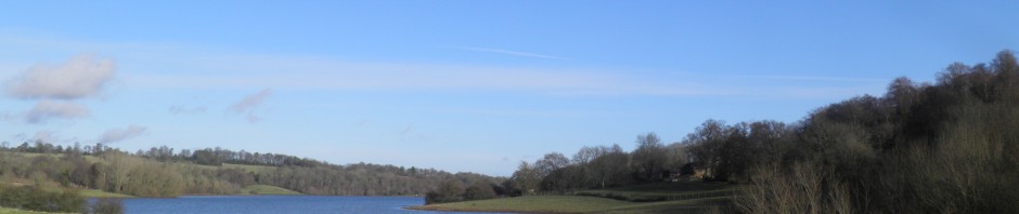
- The road curves round to run across hill-top fields. Dropping through a small wood, ignore the Bewl Water Route sign right and continue straight ahead. As the road descends, the main body of Bewl Water becomes visible, framed by the hedgerows.
Sitting right on the border of Kent and Sussex, Bewl Water is the largest area of inland water in the south east of England. Completed in 1975 by the damming of the confluence of three small valleys, which form the River Bewl, the reservoir contains 31,300 million litres of water, which supplies the Medway Towns, Hastings and Kent more widely. Despite its relative youth, the reservoir has already blended well into the local scenery and has become a valuable habitat for wildfowl, some of which you will probably see on the lake. It is also popular for sailing and rowing.
- At a t-junction at the bottom of the hill, head left. Pass a barrier and descend steeply.

Bewl Water
This was once a through road to Lamberhurst but is now completely cut off by the reservoir. Immediately before the waters’ edge, head left on a path through a small clearing beside the reservoir, with a little shelter in it.
- The path continues through woods beside the water along an inlet, before heading right and climbing to Bryants Farm Drive. Head left (signed to Wards Lane) up the drive. At the too of the hill you reach a small road.
- Turn right, but very soon head left, following Bewl Water Route signs along a broad path. After a few hundred metres of gentle descent, the path reaches the edge of a wood and turns right to drop steeply back to the water’s edge.
- At the bottom of the hill, head left (signed as ‘Round Bewl Water Walk’). The path
 continues beside the water, heading up an inlet then swinging round sharply at its head to return back up the opposite headland. Swing around the headland, the spire of Wadhurst church now visible above the trees on the hilltop.
 - The path swings around a couple of further small inlets as it wanders through the woods at the western end of the reservoir. Ignore the path signed left to Wadhurst.
- Just beyond it, you cross a small stream, immediately after which you strike left across the grass to reach a stile. Cross the stile and follow a waymark uphill beside the hedgerow.
- Reaching the top of the steep second field, follow a footpath sign slightly left and then
 swing right up a slight bank into a large grassy field. Continue to climb gently beside the ditch.
 - At the top of the hill, follow the waymark right onto a gently descending track (there is one final fine panorama of Bewl Water from here). At the bottom of the dip you join a small road at a corner. Keep straight ahead and head up the hill to the main road in the village of Cousley Wood, by the attractive Old Vine inn.
- Head left along the pavement past the inn. Continue through the village and past the junction with Monks Lane. About 100m beyond the junction, just past a house called Sadlers, cross and pass through a footgate opposite (marked as Sussex Border Path).
- Follow the broad path through a young deciduous plantation. Beyond, you cross a stile

Woods Green
and follow the fenced path around a field edge. A further stile and then a kissing gate lead you onto a path descending beside a track towards the jumbled cluster of houses at Wood’s Green.
- At the bottom of the hill, pass through a gate onto the drive of a half-timbered house and onto the road by the rather bumpy green. Head right and at the junction, turn left on Woods Green.
- The road climbs past houses and then through fields to a junction at the hilltop. Turn left towards Turners Green but almost immediately follow a footpath sign over a stile to the right. Keep to the clear path beside the left hand fence through the woodland, soon descending steadily.
- Having passed a scrap of heathland you eventually emerge on a minor road by a white cottage. Head right and at the junction right again towards Wadhurst station. Continue on this quiet, meandering road for just over 1km.
- The road descends gradually, before swinging left by the drive to grand Tappington Farm and then climbing briefly to a junction with the busy B2099. Swing sharp left here, having crossed with care. After about 50m you can head right up to Wadhurst’s fine little station house. Cross the footbridge for London-bound trains.
Wadhurst station, at a little over 100m above sea level, is the highest station in south

Wadhurst station
east England. It was when Wadhurst tunnel collapsed that the Southeastern railway realised their contractors had lined the tunnels with just four layers of bricks rather than six. Adding the additional layers made the tunnels narrow and required the use of special narrow-profile trains for this line for many years, until most of the tunnels on the route were converted to single-track in the 1980s.
